


Proje Önerisi, Bandırma Tasarım Parkı Yarışması
Açıklama Raporu (İngilizce):The Design Park in Bandırma is getting a masterplan can make a connected piece of city and create a language for future urban developments. Project that thrives on the opportunities created by thinking about its ecology and landscape, its topography and microclimate, about connections and mixed-use, and the beneficial effects of these integrated parts on commerce. Above all, to be a sustainable neighbourhood in Bandırma, this project must create a place for design and research, a great place to visit, and be a social hub.
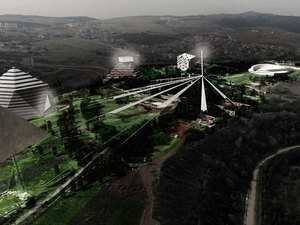
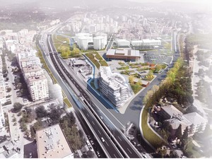
URBAN CONTEXT AND STRATEGY DEVELOPMENT OF THE IMPACT ZONE
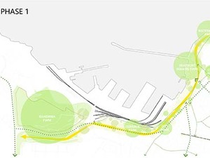
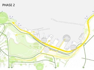
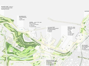
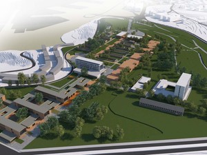
Bandırma is object of a fast urban expansion, as part of the same growth process that affects many other cities of the Marmara Region. The spread of the urban surface and the persistence of the productive activities nearby the city center deny a cohesive development of this strategic city. Bandırma aims to strengthen its role in the Region as an important hub and a city of services, without losing its productive and commercial character. Today, it is the main port on the southern coast of the Marmara Sea and, being so, it is focal for the maritime connections with Istanbul. With the recent spread of new urban settlements, Bandırma is lacking of open public spaces and facilities; furthermore, once peripheral, the commercial port and the railway are becoming very central and representing themselves a caesura between the new city and the sea. The Bandırma Park gives the opportunity to design a sustainable system of development, in line with the actual inclinations. The area of the project is crucial: in the middle of the recent urban expansion settlements, it raises as a hill overviewing the port and city. For this reason, this area is set to become the main matrix of development which opens to new scenarios in time. An urban strategy is set in two phases, according to the actual situation and the suggested views of development. In a first phase, after the completion of the Bandırma Park, the city finds new punctual open spaces and recreational areas along the main axis of connection that stretches from the area of the new Park to the existing waterfront. This axis represents a continuous green corridor that runs along the limit of the commercial port and the railway, both of them still working. For the city, it is the opportunity of regeneration of these liminal spaces, creating a homogeneous green system from the city center to the new development areas. In a second phase, after the displacement of the commercial activities away from the city, it is designed a new axis of urban regeneration passing through the dismissed port. At this moment, transversal connections allow the permeability from the city to the new urban waterfront, where new services and the main cultural facilities are located. Meanwhile, a gradient of parks, open spaces, playgrounds, courtyards, pedestrian areas is spread from the Bandırma Park to the new settlements in order to provide them with local gathering spaces and, through a dense network, eventually integrate these areas to the city center and the sea.
MAIN APPROACH TO THE AREA
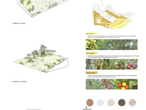
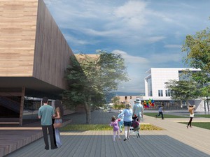
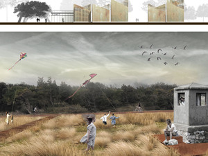
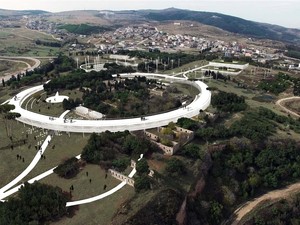
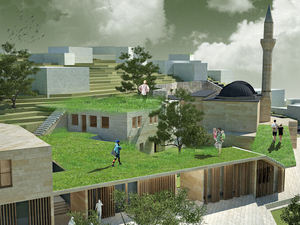
The general approach to the area and project is the idea of 'preservation'. Ruins are kept as they are because of the cultural heritage preservation. Yet, they are involved the social life of the park as open air exhibitions and cafes, restaurants. In addition to that, the preservation of the nature, plant resources and parkland is becoming the main attitude for the project area. The buildings and activities related with the design park are placed on the top of the hill. So, the area with slopes on the south east, is left as an urban park with walking paths. That paths are put above 50 cm from the earth level and do not touch the ground because of the preservation of the nature in park. The buildable area is also shaped according to preservation of existing foliage. That force is used as the main concept of the project as penetration which is the landscape penetration into the buildings.
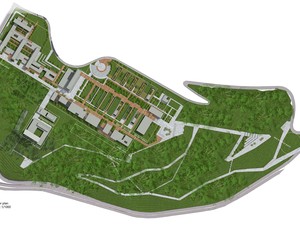
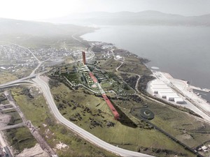
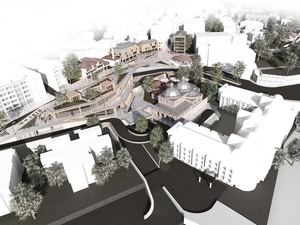
MASTER PLAN ORGANISATION
- 2 entrance points for the whole park as pedestrian access. One of that entrance point is on the east for coming people from city center and using ferry from surrounding cities. The other entrance point is on the west for coming people from the residential surrounding.
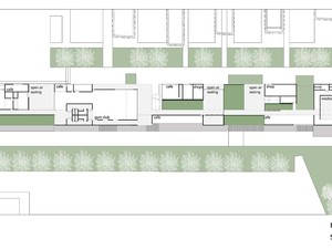
- There is a main axis which is connecting that 2 entrance point on the park. And there is a crossing secondary axis (which is very perpendicular) The main axis contains the public program of the park such as retail, design institute, open air exhibition places, ruins, green areas for social activities. The secondary axis is referring to the accommodation program of the park which is five star hotel&convention center and 4 star hotel.
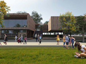
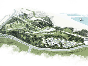
- People using east entrance point, going up by using pedestrian path and reach a square facing with the Design Institute or they can use forest road for some sport activities, walking, cycling etc., and connected the urban park on the south of the land. The pedestrian road connecting the main entrance point and main square has some terraces for viewing, resting and steps for sitting.
- People using west entrance point reach the retail park contains big part of lettable area and facing with the main axis on the south and sea view on the north. After that accommodation cross axis is reached.
- Ruins are used for exhibition pavillions, open air exhibition areas and some cafes, restaurant with their private gardens.
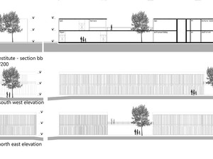
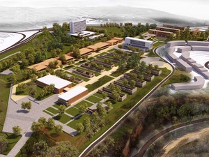
DESIGN INSTITUTE
Design Institute has a frontage with the main square. There is a passage between design institute blocks which is accessing production and sharing spaces in and around ruins. A block contains the study part of the program like lecture rooms, meeting rooms, auditoriums, multimedia and administration. B block is more public part of the building. Main hall with bookshop, cafe and foyer are placed at the ground level. At the upper level, library and fabrication workshops are placed with a terrace. Blocks are connected to the each other with a bridge.
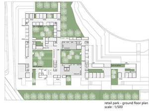
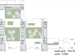
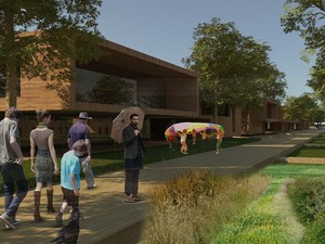
RETAIL PARK
The Retail Park is accessed from the west entrance point. And it goes along the main axis going through east entrance point. Main idea for retail park is getting continous relation with the pedestrain roads, open air spaces, platforms, terraces, gardens at different levels. Existing trees and landscape penetrates the retail blocks and getting more surface for defining the open space and closed space relations. The retail block which is at the very center of the settled area on the main axis, contains some productivity areas like handcraft ateliers. That spaces and small retail shops can be hired by citizens of Bandırma . While producing their own products they can sell also. It is the idea of production and consumption being together in that design park. The large green roofs on these retail buildings are proposed to be put into use as productive gardens also.
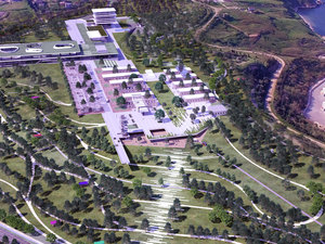
The Retail Park also accessed by car from Erdek Yolu Street. The entrance part of that side is used as an open air car parking area and it can be used for all users of the park. Cars can through until the axis of accommodation and the cross part is just pedestrian. That road is also used for emergency and service.
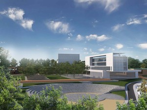
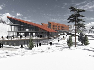
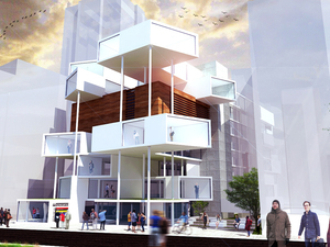
HOTELS & CONVENTION CENTER
Hotels and convention center is sited along the secondary axis on the north-east and south west direction of the master plan to be separated from the main retail and pedestrian axis. On the other hand they are still a part of the urban frame rather than being isolated. Five star hotel and convention center is at the back of the land. While five star hotel is a bit higher than the other building and settlement on the park, it is not interrupted sea view because of its location. The rooms of five hotel look through the sea. The base of the hotel is more public and allows the retail, café and restaurants. The terrace of the base is used as private outdoor garden.
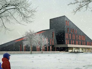
Four star hotel is on the north of the accommodation axis and it is in between the public facilities and design institute. So, the base of four star hotel is more public than the five star hotel base and also contains more retail and public access.


Tweet